The Seskin viewpoint above Bantry Bay is one of the best free stops on the Wild Atlantic Way, and the perfect way to start a day exploring West Cork. Set on high ground just outside Bantry town, it looks out over a 30-kilometre sweep of bay, scattered islands, and sheep grazing on impossibly green hillsides, with the Caha Mountains rising on the far shore. Here’s where to find it, what you’re looking at, and why it’s worth pulling over for.
The View That Made Me Pull Over
There are views you appreciate, and there are views that stop you mid-sentence. The Seskin viewpoint above Bantry Bay is firmly the second kind.
I’d been driving west from Cork for about an hour and a half, already won over by the way the Irish countryside kept insisting on being greener than anything I’d seen before, a green so vivid it looks as though someone has nudged up the saturation on the whole country. Then the road climbed, the hedge dropped away on one side, and Bantry Bay opened up below me.
I pulled over. I got out. I stood there in the wind a good deal longer than I’d meant to.
Where Exactly Is Seskin?
The Seskin viewpoint sits on high ground just above Bantry town, on the road running south-west toward the Sheep’s Head and Mizen Peninsulas. It’s an official viewpoint, with a low stone wall, a metal railing and a large illustrated board put up by the Bantry Business Association, but it doesn’t feel manicured. It feels more like someone built a wall at the edge of a hillside so you wouldn’t topple off it while standing there with your mouth open.
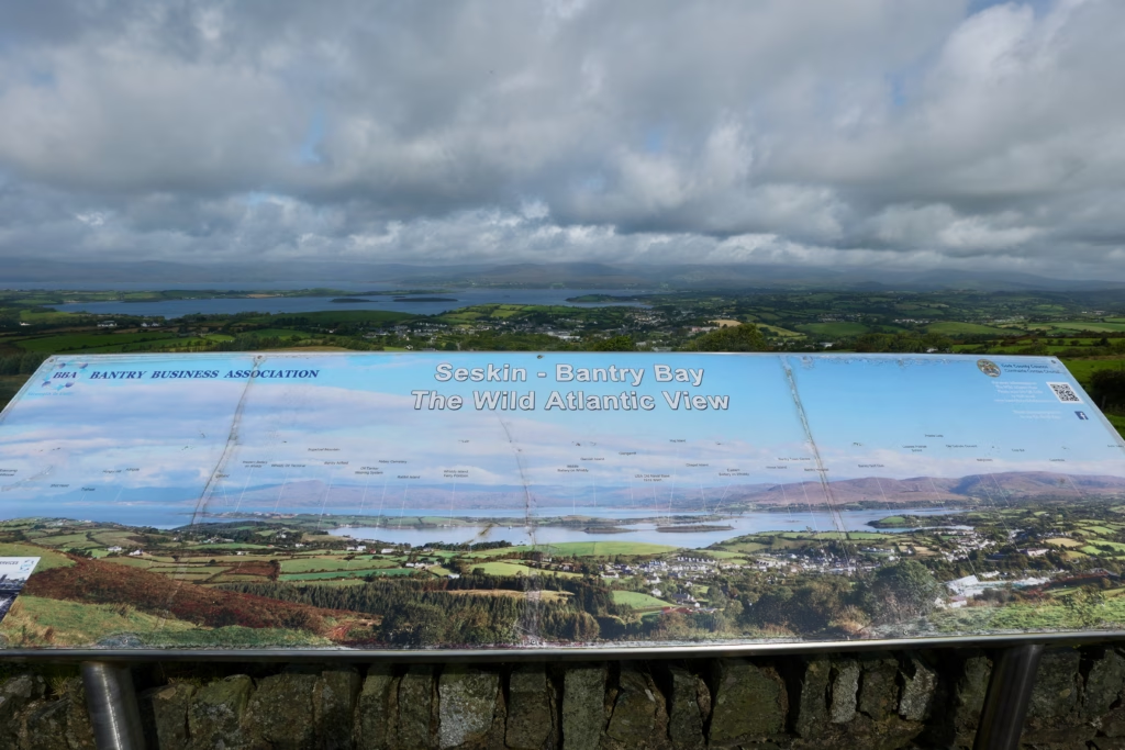 The official Bantry Business Association information board at the Seskin viewpoint, identifying landmarks across Bantry Bay
The sign reads Seskin – Bantry Bay, The Wild Atlantic View. It’s a good name, and it earns it.
What You’re Actually Looking At
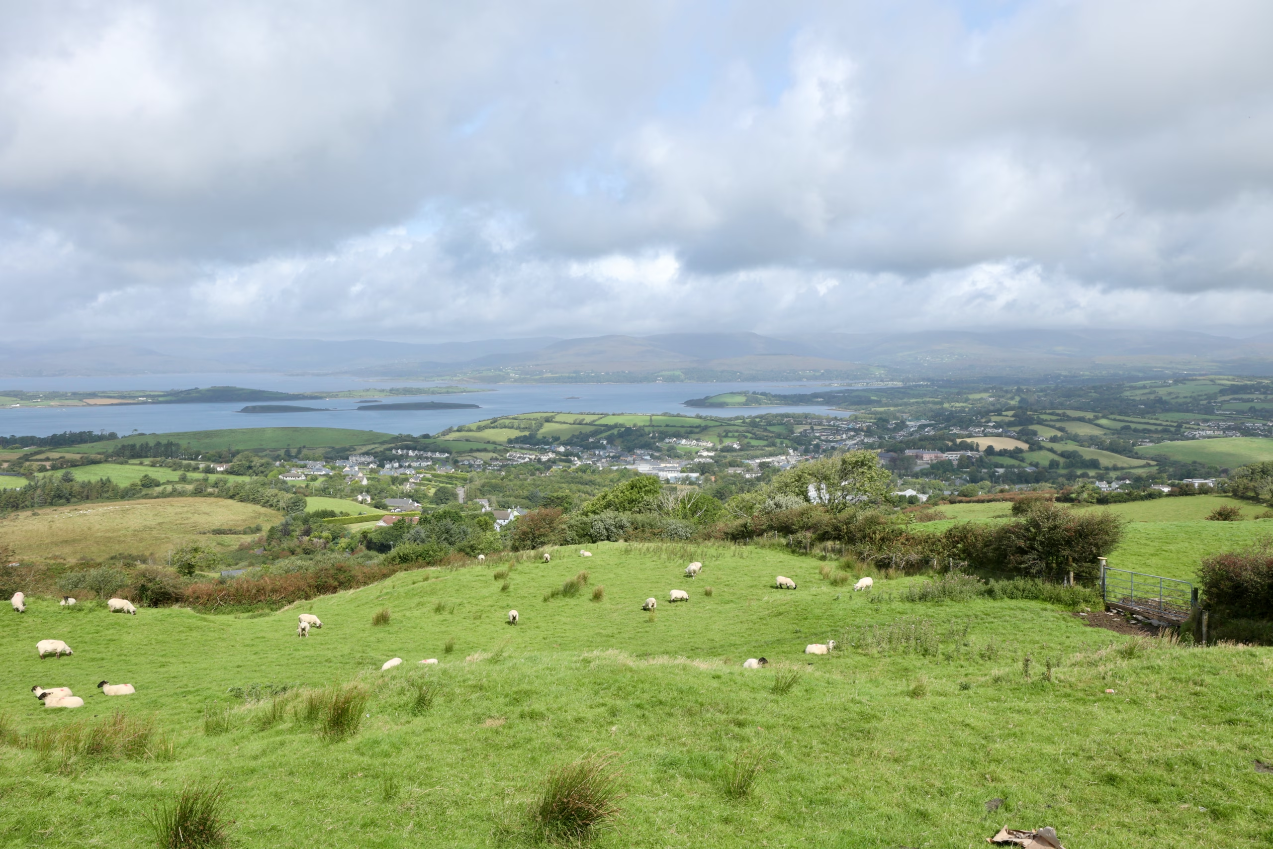
 Looking down at Bantry town from the Seskin viewpoint, with the bay behind and sheep on the hillside foreground
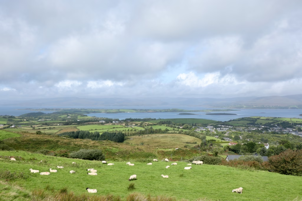
From up here Bantry town sits below you like a model village: white houses, church spires, the edge of the harbour. Beyond it, Bantry Bay runs inland for more than 30 kilometres, one of the longest and deepest natural harbours in Ireland. On a clear day you can see across to the Caha Mountains on the far shore, dark above the water.
The bay is dotted with small islands, flat green shapes that look as though they’ve been there since long before anyone thought to name them. The board on the wall picks them out: Whiddy Island, the largest, with its oil terminal; Heir Island; Garinish Island. Each carries its own history, including, in Whiddy’s case, the 1979 Betelgeuse tragedy, a tanker disaster the town still remembers. From up here, though, they’re simply shapes in the silver water.
What makes this view work so well, better than plenty of more famous viewpoints in Ireland, is the layering. The electric green of the sheep pasture in the immediate foreground. Then the rooftops of Bantry. Then the dark blue-grey of the bay. Then the patchwork of fields on the far shore. Then the mountains, soft and muted, fading into cloud. Five distinct layers, all in a single frame.
The Sheep Are Part of the Experience
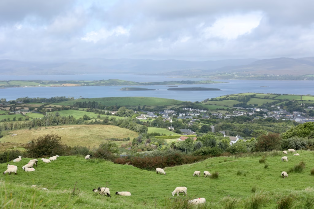
 Sheep on the Seskin hillside above Bantry Bay — the best composition of the whole viewpoint stop
I want to put in a word for the sheep, because they’ve earned it.
All over the Seskin hillside, grazing, dozing, wandering with total indifference to the view and to me, were sheep. Dozens of them. Black-faced, cream-woolled, scattered across the green as if dropped from above. The wind didn’t bother them. The view didn’t bother them. I certainly didn’t bother them.
There’s something about watching sheep graze against a vast Irish bay that resets your sense of what matters. They hold no opinion about Bantry Bay. They’re just in it, the way everything here seems to just be in it, unhurried and entirely at ease.
The Wind
On the subject of weather: it is very, very windy up here. That’s not a complaint, just useful information. Seskin sits on exposed high ground at the edge of West Cork, and when the Atlantic decides to send something inland, there’s nothing between you and it but a low stone wall. My jacket did its best. My hair had given up inside about forty-five seconds.
Bring a layer you can zip right up. That goes for August. I dread to think what November is like.
The Road to Get Here, and Why It Matters
The drive up to Seskin is worth describing in its own right, because it’s a perfect introduction to what West Cork roads are like and what they do to your sense of where you are.
The lane that climbs from Bantry to the viewpoint is narrow. Not “narrow for Ireland”, just narrow. The hedgerows press in on both sides. Gates open straight onto the road with no verge and no warning. A faint stripe of grass runs down the middle where the tarmac doesn’t quite reach the edges. You drive at the speed the road dictates, slower than you expected, and the slowness turns out to be the point.
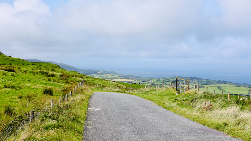 The road from Seskin looking south and west toward the Atlantic. This is what the roads are like. You’ll slow down whether you mean to or not.
This is one of the things I keep returning to about West Cork: the infrastructure hasn’t been smoothed into anonymity. The roads are still the old roads, the gates still the old gates, the hedgerows uncut back for a kerb and a passing bay every fifty metres. Because of that, you get the persistent, slightly disorienting feeling of being somewhere that wasn’t laid out for you specifically, somewhere that was simply here before you came and will be here after you’ve gone.
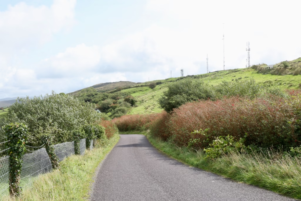 A typical West Cork lane in late August — fuchsia in full flower, hedgerows pressing close, barely wide enough for one car
It was on one of these lanes, with the hedges so close the red fuchsia was brushing both windows, that I understood what people mean when they call Ireland untouched. It isn’t untouched, of course; people live here, farm here, drive these roads daily. But it is un-smoothed. The edges are still there.
The Other View: Looking East
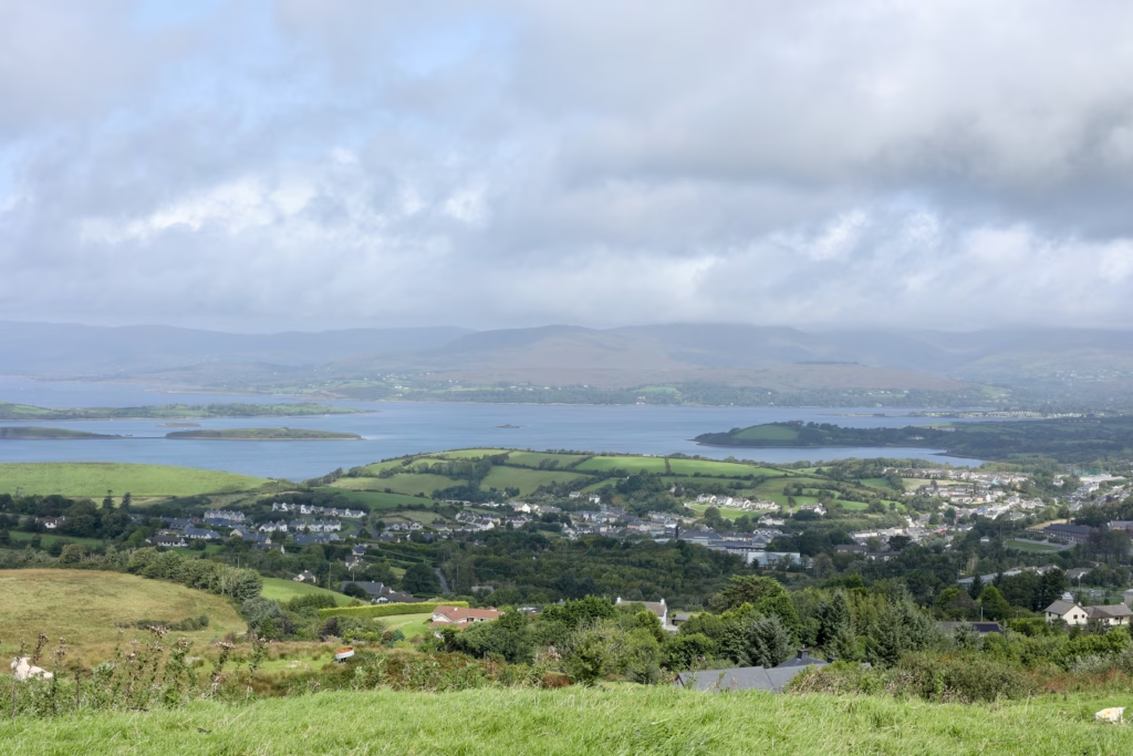 Bantry town spread across the valley floor with the bay behind and the mountains of Kerry disappearing into cloud
One direction most visitors never photograph at Seskin is east, away from the bay and toward the interior of West Cork. Turn your back on the water and you get something quite different: rolling hills, patchwork fields in a dozen shades of green and gold, Bantry spread along the valley floor, and beyond it the mountains of Kerry with cloud draped over their upper slopes like a grey scarf.
Ireland is a small country. On the right day, the view from Seskin shows you three counties at once.
Seskin: Practical Information
The viewpoint is on the R586 Bantry to Durrus road, roughly 3km from Bantry town centre, signed from the road; watch for the Wild Atlantic Way marker and the stone-wall viewpoint on your right as you head south-west. Coming by car from Cork, take the N71 west to Bantry, about 90 minutes, then follow the R586 toward Durrus, and you’ll find the viewpoint on the right after about 3km on the uphill stretch.
There’s a small pull-in at the viewpoint with room for three or four cars, and it fills quickly on summer weekends, so arriving before 10am or after 4pm saves you the scramble. Twenty to thirty minutes is plenty to stand, look, take photos, read the board and breathe, though allow longer if you’re the sort who likes a moment to simply be somewhere. It’s free, with no entry or parking fee, and there are no facilities on site; Bantry, 3km back, has cafés, restaurants and a supermarket.
As for timing, the view holds up in almost any light: overcast days give the bay a silvery drama, sunny days make the green almost too much, and early morning or late afternoon are best for photography. One note on access: the standing area at the wall is flat and roadside, but the lane up is steep and narrow and not suited to large vehicles or coaches.
Is It Worth Stopping For?
Yes, without hesitation. It takes maybe twenty minutes out of your day, costs nothing, and gives you, if you catch it right and the light is doing what West Cork light does, a view of Ireland you’ll still be able to close your eyes and see months later.
The Seskin viewpoint isn’t on most Ireland itineraries. No car park, no café, no ticket. Just a wall at the edge of a hill, with one of the quietly most spectacular views in the country behind it.
Stop. Get out. Let the wind do whatever it likes to your hair.
What’s Nearby
Seskin is the natural first stop on a longer day exploring the Mizen Peninsula. From here the road carries on south-west through Durrus and onto the peninsula itself, toward Brow Head, Galley Cove Beach, Mizen Head Bridge and the ruins of Three Castle Head.
Read the full Mizen Peninsula day trip guide
Bantry also makes a good base for going further afield. With more days to play with, the Ring of Kerry Guided Day Trip from Cork and the Full-Day Tour to Dingle Peninsula from Cork are two of the best guided day trips in the country, both reaching scenery that rivals anything in West Cork.
Have you stopped at the Seskin viewpoint? Drop a comment below, I’d love to know what you made of it.
Enjoyed this? Save it to Pinterest or share it with someone planning a West Cork road trip.
Please visit:
Our Sponsor
Related Posts

How to run a hotel with fewer staff – without compromising experiences
Rising costs, a shrinking labor pool and soaring guest expectations…

Lighthouse launches Smart Distribution to automate pricing and channel management for independent hotels
LONDON, UK – Lighthouse, the leading commercial platform for travel…

State Library Victoria: The Most Beautiful Free Thing to Do in Melbourne
Nobody told me to go to the State Library Victoria.…